The Lost City of Atlantisnt
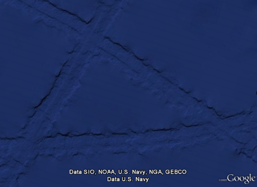
Some combination of internet-fed conspiracy theorists and Google Earthlings (lings that use Google Earth) were abuzz last week with an odd image find, possibly representing the lost city of Atlantis:

These hopes were later dashed (or perhaps only fed further) when the apparition was denied in a post on the Official Google Blog crafted by two of the gentlemen involved in the data collection for Google Ocean. The post is fascinating as it describes much of the process that they use to get readings of the ocean floor. They explain how echosounding (soundwaves bounced into the depths) is used to determine distance, and when that’s not possible, they actually use the sea level itself:
Above large underwater mountains (seamounts), the surface of the ocean is actually higher than in surrounding areas. These seamounts actually increase gravity in the area, which attracts more water and causes sea level to be slightly higher. The changes in water height are measurable using radar on satellites. This allows us to make a best guess as to what the rest of the sea floor looks like, but still at relatively low resolutions (the model predicts the ocean depth about once every 4000 meters). What you see in Google Earth is a combination of both this satellite-based model and real ship tracks from many research cruises (we first published this technique back in 1997).
How great is that? The water actually reveals shapes beneath because of gravity’s rearrangement of the ocean surface.
A more accurate map of the entire ocean would require a bit more effort:
…we could map the whole ocean using ships. A published U.S. Navy study found that it would take about 200 ship-years, meaning we’d need one ship for 200 years, or 10 ships for 20 years, or 100 ships for two years. It costs about $25,000 per day to operate a ship with the right mapping capability, so 200 ship-years would cost nearly two billion dollars.
Holy crap, two billion dollars? That’s real money!
That may seem like a lot of money…
Yeah, no kidding — that’s what I just said!
…but it’s not that far off from the price tag of, say, a new sports stadium.
Oh.
You mean this would teach us more than New Yorkers will learn from the Meadowlands Stadium debacle, beyond “the Jets still stink” and “Eli Manning is still a weenie”? (Excellent Bob Herbert op-ed on a similar topic — the education part, not the Manning part.)
So in the end, this “Atlantis” is the result of the rounding error in the patchwork of data produced by the various measurement and tiling methods. Not as exciting as a waterlogged and trident-wielding civilization, but the remainder of the article is a great read if you’re curious about how the ocean images are collected assembled.

